|
Kinnickinnic River
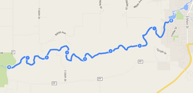
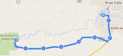
Tennis Courts in River Falls to County F Bridge - 7.7 river miles This is about 2 to 3 hours depending on your speed - 7.6 road miles A pretty easy ride back to the car Notes: - Park by the tennis court at Glen Park in River Falls. - This is a really nice paddle, but the river is fairly narrow and you will have to avoid some down trees and other debris. - The first hill to Cty Road FF is a steep one |
|
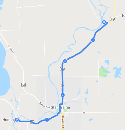
Apple River
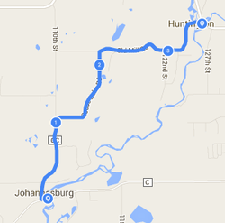
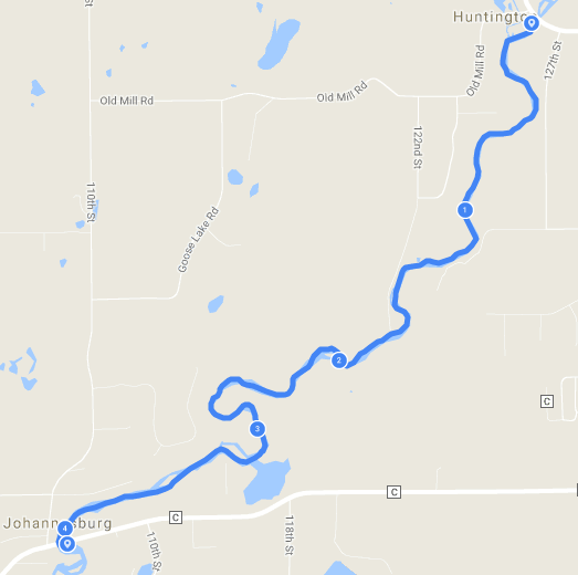
Huntington Landing to Johannesburg Landing - 4.2 river miles This is about 1 hour & 15 minute paddle - 3.6 road miles A pretty easy ride back to the car Notes: - The Huntington Landing is near Cedar Creek Inn and the Johannesburg Landing is across the road from the Outpost Bar & Grill. - This is a pretty short route, but can be increased by starting at the park in Star Prarie, or go further to Riverdale Flowage. - To extend further you can start on Church road off of Hwy 65 north of Star Prairie or even further north off Random drive (low bridge), or further down Random drive (high bridge). - Or go further to the Riverdale flowage. - With the Outpost bar at the exit point, the rest of the paddling party can hang out there while the biker heads back to the car. |
|
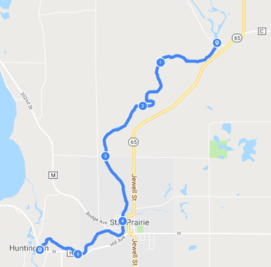
Apple River
Church Road to Huntington Landing
- 5.7 river miles
This is about 1 hour & 45 minute paddle
- 4.75 road miles
Short ride, but not on a bike friendly road
Notes:
- There is no official parking spaces at Church road landing, you have to park on the shoulder off the road. Make sure you note the No Parking signs by the bridge.
- This has more active water and exposed rocks around Star Prairie, where a beginner paddler may have problems or an intermediate paddler can't be complacent when going through the rapids.
- Highway 65 is the shortest and fastest way back, but there is no real shoulder to ride on and the highway can get busy. So, it would be more unsettling for inexperienced bikers. Wear a bright shirt and have a flashing taillight if possible.
|
|
|
|
St Croix River
Soderback landing to Hwy 70 - 4.6 river miles This is about a 2 to 3 hour paddle - 6 road miles (all paved) Just take Hwy 70, north on Soderback, then left on Ferry Rd Notes: - This is a pretty simple bike route to get back to the car with the biggest annoyance being riding a couple of miles on Hwy 70 - Going out of Fox would be doable but would make the bike route 14.5 miles and about 9 miles in the kayak, so add 2 to 3 hours |
|
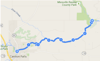
Cannon River
Riverside Park in Cannon Falls to Miesville Ravine - 7.2 river miles - 7.2 road miles (1st 2/3rds was on gravel) Notes: - The river route started at Riverside Park in Cannon Falls - For this route it ended at Miesville Ravine County Park, which is when you see the power lines - It's about a 2 to 3 hour paddle - The 1st hill out of the Miesville Ravine is a steep climb |
|
|
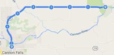
Cannon River
Welch Village to Highway 61 - 7.5 river miles, 3 to 4 hours float time - 6 or 7.7 road miles (depends on which route you want to take) Notes: - This stretch of the river is not the main section used by the outfitters, so there are a lot more trees in the water - This stretch does have a lot of bends, so between the down trees and bend, you need to be a little more cautious so you do not get hung up in a bunch of branches (like I did). - There is no official public landing in Welch, but the Welch Mill outfitter charges $5 to launch from their entry point. - You could probably find a free place to park and go-in, but $5 is pretty reasonable to support the local business - The exit point, off Green Spring road, is right before the Hwy 61 bridge (so impossible to miss), the banks are fairly steep so it's not an easy take out. - There are 2 decent bike routes back to Welch: + There is a shorter route (6 miles), but on a gravel road and hilly. Nice ride to see the countryside. This route runs north of the river. +The longer route is along the Cannon Valley Bike trail (7.8 miles). A great bike trail that is pretty flat and no cars. - Both rides are scenic, so my suggestion is to do this float twice and try both bike routes. - If you do the Cannon Valley Bike trail and want to keep the ride as short as possible, then don't miss the Cannon Bottom Rd left turn. I missed the turn and ended up riding to the Cannon Valley trailhead another couple miles down the road. It was still a nice ride, but just 5 miles longer. - As I mentioned, I did get hung up in a down tree and flipped my kayak. Even though I ended up losing some of my gear, I didn't feel like it was a life threatening situation at all. The river wasn't moving that fast, but it still creates a powerful force when your kayak is trapped sideways. |
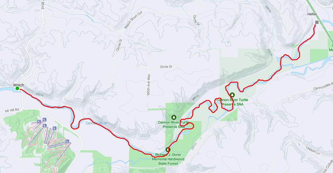
Cannon River kayak float
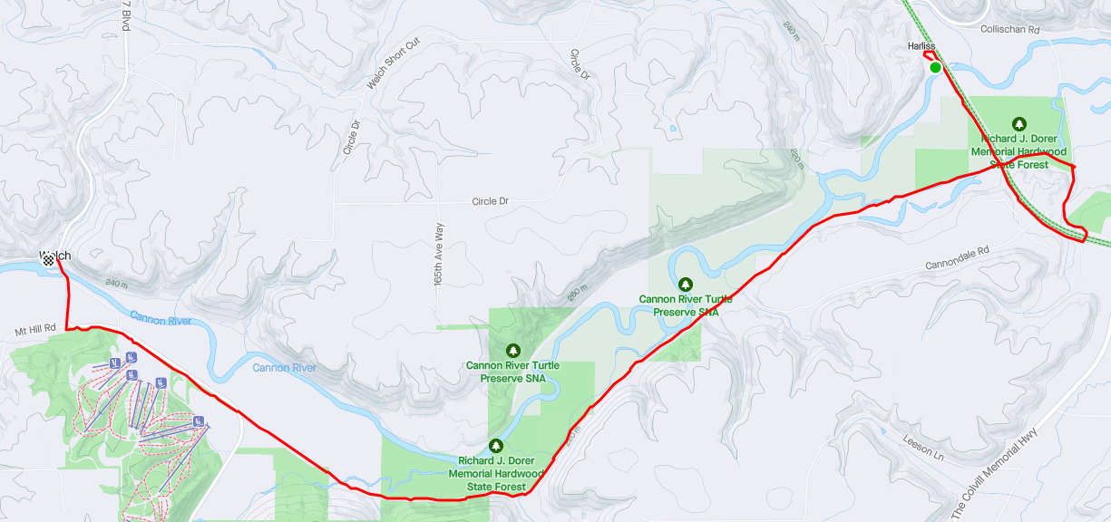
Cannon Valley bike trail
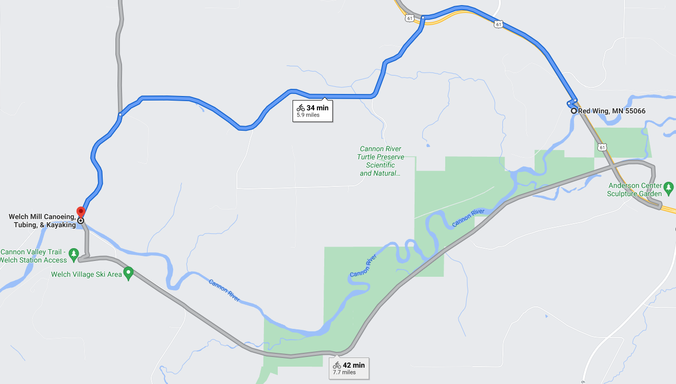
Welch Short Cut gravel road
|
|
|
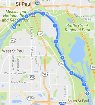
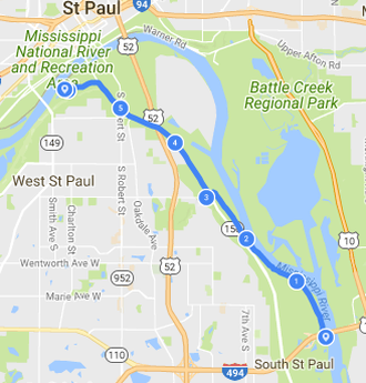
Mississippi River - Downtown St Paul to Wakota Bridge
Started from Kelley's Landing at Harriet Park Regional Park and at the Wakota bridge. Both are nice and easy places to start or end a route.
This is an easily accessible 7.5 mile route right in the city, but you have to deal with the industrial part of the river - many parked barge, cement levees, & debris. It's an easy 6.2 mile ride back to Harriet Island.
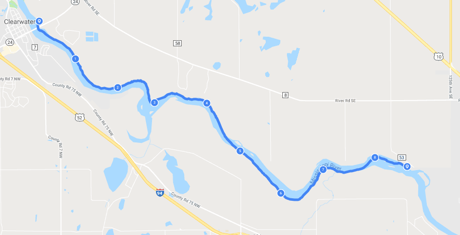
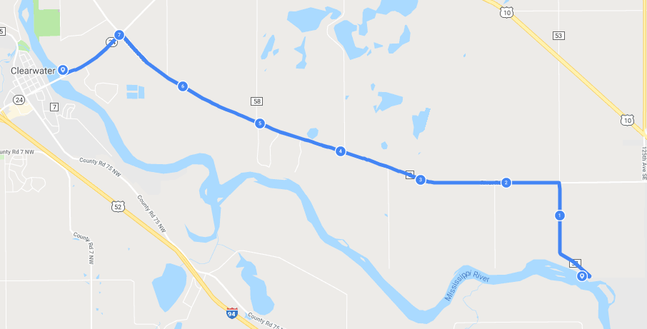
Mississippi River - Clearwater to Snuffy's Landing
Start at the public landing across the river from Clearwater. This stretch of river is a nice gentle float where there is an equal amount of houses and wild shoreline. Good fishing spots all the way down the river.
Both the river entry and exit points are easy to get in and out. and is about 8.6 river miles, so expect to be on the river for 3 to 4 hours. However, I didn't see any public places between the take-in or take-out spots for breaks. The ride back is 7.8 miles long and mainly on a county highway, but there is a nice wide shoulder to ride on.
|
|
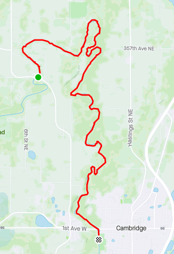
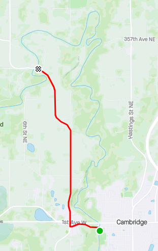
Rum River - North of Cambridge
With the length of the Rum river there are many entry and exit points, so there is plenty of options. This route, out of Cambridge, was picked since it maximized the river distance compared to the biking distance. There is 8.6 river miles compared to 3.5 miles back to the entry point. This stretch of river is very winding, so you don't travel that far "as the bird flies". The river is not nearly as wide as the St Croix or Mississippi, but wide enough to make it pretty easy to paddle. And its a good place to fish for bass.
The entry point right off of County road 14 (Polk/Quincy road) is just north of Cambridge is a pretty basic boat access, but no problem for canoe/kayaks. The Cambridge City Park provides a nice place as an exit point and to lock up the bike. There is another official boat launch on the other side of the river and park on the north side of the 2nd Ave.
|
|
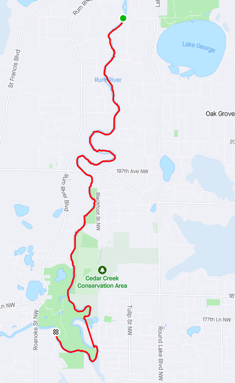
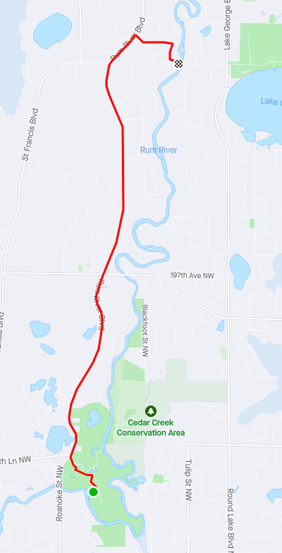
Rum River - South of St Francis
This stretch is all contained in the city of Oak Grove, where the entry point is on the west bank of the Rum off 219th Ave and Rum River Blvd, and the exit point is in the Rum River Central Regional Park. In the Regional Park you can take out at either the boat ramp or go another 2 river miles to a canoe landing.
The DNR river map stated that from the entry point to the canoe landing is 8.5 miles, but the GPS tracker recorded almost 9.5 miles. So, the trip was another hour longer than what was planned.
The river in this section is fairly similar to the up-river sections, but a little wider. The river bottom in this section is a little more varied than the up-river section, where there are a bunch of sections that are very sandy.
This fishing was still good, but there were a lot of small bass, along with enough bigger bass.
|
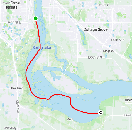
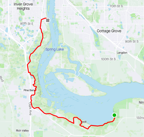
Mississippi River
River Front Park to Spring Lake Park This has been the longest paddle-pedal route I've done at 9.6 miles. It took 4.5 hours without any stops. River Front Park is a nice hidden, small gem of a waterfront park. Besides easy access to the water, it's also a great place to just hang out at the waters edge. Unlike the other 2 Mississippi routes (Clearwater & Harriet Island) this one had a lot of recreational boat activity. Since I stayed near the shore there was never an issue with them getting too close, but you do have to deal with their wakes. The 13 mile ride back is longer than I would prefer (since I just spent almost 5 hours on the water), but it is mainly on a nice bike trail. So with that distance you can expect another hour to be added to the trip. Still need to do this some day Hidden Falls to Harriet Island Around Pike Island paddle both the Minnesota and Mississippi rivers in one trip |
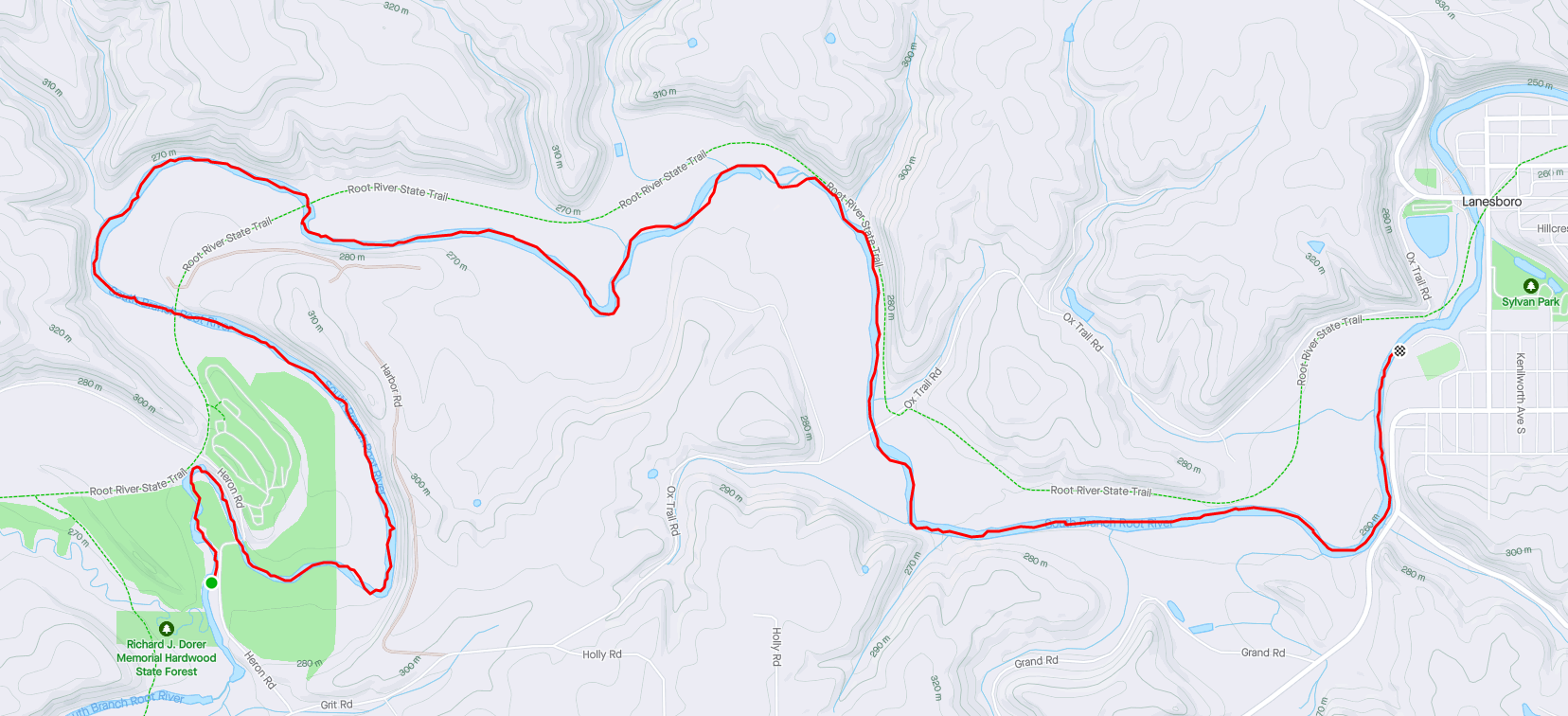
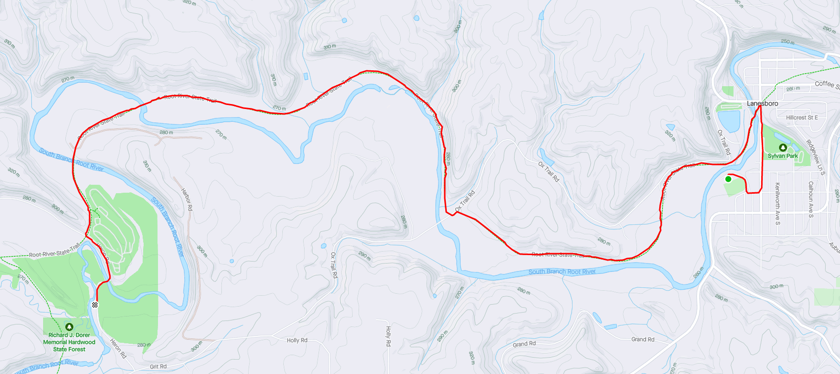
Root River
This paddle/pedal routes in Lanesboro on the Root River became one of my favorites. I locked the bike up at Riverview Campground located just off Pleasant St W. The kayak take-out point is past the end of the campground parking lot northwest of the football field. It is basically the last spot you can get out before the dam.
The entry point is at the DNR entry point is right by the Old Barn Resort off Heron Road. This segment of the river is almost 7 miles and will take 2.5 to 3 hours to float.
The ride back from Lanesboro to the Old Barn Resort is a flat 5.5 miles back on the Root River Trail.
At normal levels, the river is an easy float where the worse thing to look out for are a few shallow channels and dead trees in the stream.
|
Minnehaha Creek
I definitely want to do this some day, but have not researched on where the best place to put in and take out near a good bike route. Notes: |

|
